Königstein - Ebenheit - Lilienstein - Sellnitz -Königstein = 5 kilometers = about 2 hours

Marking : EB and a blue wipe of paint. Pretty steep descent and ascent. The climb of the Lilienstein is part of the international walking trail
The EIbe ferry boat links the Halbestadt part of town with Königstein . A couple of steep hairpin bents brings you up to the Ebenheit, with its farmlike country-side and villageture which was alraeady mentionned as existing in 1489
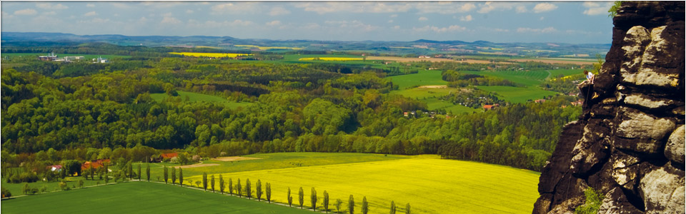
From this fertile loessclay covered Ebenheit, you can see the Lilienstein presenting its broad side.
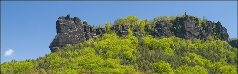
The summit's surface is decomposing itself in separate rock pinnacles and needles and drops a sheer 60 till 80 meters right down to the foundations.
These foundations have a 30° inclination and are surrounding the entire mountain. It is this inclined foundation that gives the Lilienstein its typical table mountain appearance. These foundations are merely composed by weathering debris and are covered with a pine forest, which can oppose the danger of
erosion on the steep slopes. Coming from the south, on the south hang one can reach the summit at 415 meters height after climbing steel staircase constructions From the Elbe-river level, one has then mastered a difference in
height of 300 meters. This same climb was made by King August the Strong One in 1708. An obelisk near the TV Antenna reminds of this event. A much larger obelisk, in the middle of the south hang is commemorating the celebration of the 800 year existence of the reigning saxon Wettin family. The Restaurant in the Rocks is open each day from Eastern till the end of October, from 10 a.m. till 5 p.m. daily. If you would like to organize an event, a party or a group meeting on the Lilienstein, please call 035022.40943 or the Hotel at 035022.530
For the rest of the time, please call the Hotel first, as we know exactly when and if they are open up there on the rocks.


Thanks to its central location, the Lilienstein is offering a stunning 360° view on Saxon Switzerland. You will have to make the entire tour of the summit, though, to enjoy this vision.
In the North you can see the Brand-and Ochelwalls, the Napoleon entrenchment at Hohenstein, Stolpen and the
The name of the Lilienstein came from the holy man Aegidius ( Saint Gilgen = Sankt Jilgen ). The first mention by charter dates from 1379 ( Ylgenstein) Then,
the orthography changed over the centuries, until becoming the actual Lilienstein. Due to its dominant geographic location and its proximity to the
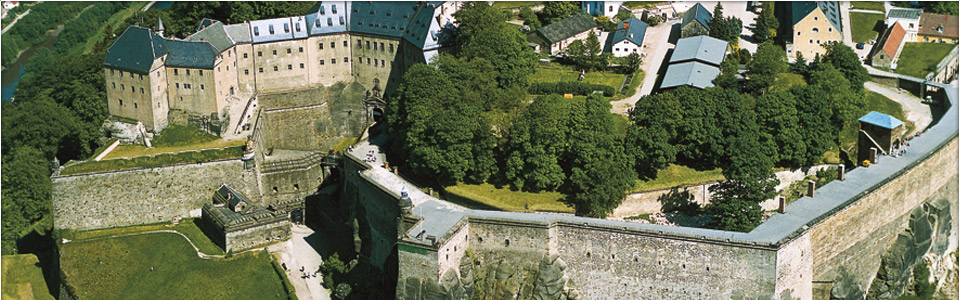
Königstein fortress, the Lilienstein had already in 1396 a military force on its platform. Remains of walls and buildings still can be seen, and soil research and discoveries such as arrow heads, knives, bolts and nails were achieved.
In 1756 and 1813 the Lilienstein area became an important military section. To this the " Kaiserstrasse " still refers, just as the remains of entrenchments and the Franzosen-Well in the forest near the Lilienstein.
Since the mid-nineteenth century, a " flying inn " was mentionned to exist on the summit of the Lilienstein, and even today a Mountain Inn and Restaurant operates during the summer months only.
By the Northern descent, constructed only in 1900, one can reach Sellnitz, now a suburb name only. But once an independant village, mentionned al ready at the end of the 15th century. From here, and the nearby Franzosen-Well, you can reach across a narrow terrace over the former quarry the forest fringe and the steep descent to the banks of the Elbe.
Reservierung
Hotelbewertung

Sky
Alle Zimmer verfügen
über SKY-Empfang!
Marco Polo
